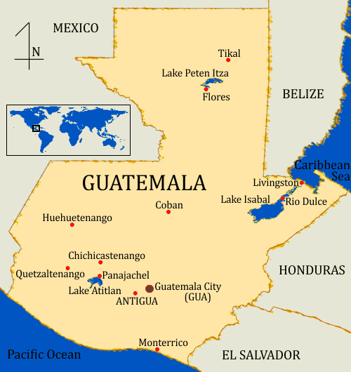
Guatemala Map
The map to the right shows Guatemala's main travel destination and some of it's principal cities.
There are a number of good map sites on Guatemala, not the least of which is Google Maps, however it can be difficult to find small but popular destinations. Use the map to the right to get a rough idea of where what you want to see close up is, then go to Goole Maps and zoom in.
The CIA has an informative site called The World FactBook. Go to their page on Guatemala. There is much more data there but some of the more important information follows:
- Population: 14,647,083 (July 2014 est.)
- Ethnic groups:
- Mestizo (mixed Amerindian-Spanish - in local Spanish called Ladino) and European 59%
- K'iche 9.1%, Kaqchikel 8.4%, Mam 7.9%, Q'eqchi 6.3%, other Mayan 8.6%, indigenous non-Mayan 0.2%
- Languages:
- Spanish (official) 60%
- Amerindian languages 40% ~ There are 23 officially recognized Amerindian languages spoken in Guatemala.
- Area: 108,889 sq km ~ 42,042 sq mi
- Highest Point: Volcanoe Tajumulco 4,211 m ~ 13,816 ft
- Independence: 15 September 1821 (from Spain)